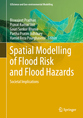
Spatial Modelling of Flood Risk and Flood Hazards: Societal Implications
暫譯: 洪水風險與洪水危害的空間模型:社會影響

Pradhan, Biswajeet, Shit, Pravat Kumar, Bhunia, Gouri Sankar

  • 出版商: Springer
  • 出版日期: 2022-04-07
  • 售價: $7,280
  • 貴賓價: 9.5$6,916
  • 語言: 英文
  • 頁數: 238
  • 裝訂: Hardcover - also called cloth, retail trade, or trade
  • ISBN: 303094543X
  • ISBN-13: 9783030945435
  • 海外代購書籍(需單獨結帳)

商品描述

Floods and flash floods with hydro-meteorological and tropical cyclones are the some of the most devastating natural disasters causing massive damages to natural and man-made features. Flood hazards are a major threat to human life, properties (agricultural area, yield production, building and homes) and infrastructures (bridges, roads, railways, urban infrastructures, etc). Flood hazards susceptibility mapping (risk assessment) and modelling is an essential step for early warning systems, emergency services, prevention and mitigation of future environmental and social hazards and implementation of risk management strategies. Due to the lack of proper information, technology-based policies and strategies, mapping and modelling can often not be implemented to the best possible level. Geo-spatial techniques have enjoyed rising interest in recent decades among the earth environmental and social sciences research communities for their powerful ability to solve and understand various complex problems and develop novel approaches toward sustainable earth and human society.

By linking geo-spatial computational intelligence techniques with societal and environmental-oriented problems, this book demonstrates geospatial technology approaches to data mining techniques, data analysis, modelling, risk assessment and visualization and management strategies in different aspects of flood hazards. We believe that a diverse group of academics, scientists, geographers, hydrologist, remote sensing and GIS expertise, environmentalists, meteorologists and computing experts with a common interest in geospatial sciences within the earth environmental sciences and humanistic and social sciences will find this book to be of great value.

商品描述(中文翻譯)

洪水和瞬間洪水以及水文氣象和熱帶氣旋是造成自然和人造特徵重大損害的一些最具破壞性的自然災害。洪水危害對人類生命、財產(農業區域、產量、生產建築和住宅)以及基礎設施(橋樑、道路、鐵路、城市基礎設施等)構成了重大威脅。洪水危害易感性地圖(風險評估)和建模是早期預警系統、緊急服務、未來環境和社會危害的預防與減輕以及風險管理策略實施的重要步驟。由於缺乏適當的信息、基於技術的政策和策略,地圖製作和建模往往無法達到最佳水平。近幾十年來,地理空間技術在地球環境和社會科學研究社群中受到越來越多的關注,因為它們具有解決和理解各種複雜問題的強大能力,並開發出可持續的地球和人類社會的新方法。

本書通過將地理空間計算智能技術與社會和環境導向的問題相結合,展示了地理空間技術在洪水危害的數據挖掘技術、數據分析、建模、風險評估、可視化和管理策略等不同方面的應用。我們相信,對地理空間科學在地球環境科學和人文社會科學中有共同興趣的學者、科學家、地理學家、水文學家、遙感和GIS專家、環保人士、氣象學家以及計算專家等多元化群體會發現本書具有很大的價值。

作者簡介

Prof. Dr. Biswajeet Pradhan is an internationally established scientist in the field of Geospatial Information Systems (GIS), remote sensing and image processing, complex modelling/geo-computing, machine learning and soft-computing applications, natural hazards and environmental modelling and remote sensing of Earth observation. He is the Director of the Centre for Advanced Modelling and Geospatial Information Systems (CAMGIS) at the Faculty of Engineering and IT. He is also the distinguished professor at the University of Technology, Sydney. He is listed as the World's most Highly Cited researcher by Clarivate Analytics Report in 2019, 2018, 2017 and 2016 as one of the world's most influential mind. In 2019 and 2018, he has been awarded as World Class Professor by the Ministry of Research, Technology and Higher Education, Indonesia. He is a recipient of Alexander von Humboldt Research Fellowship from Germany. In 2011, he received his habilitation in "Remote Sensing" from Dresden University of Technology, Germany. Since February 2015, he is serving as "Ambassador Scientist" for Alexander Humboldt Foundation, Germany. Professor Pradhan has received 55 awards since 2006 in recognition of his excellence in teaching, service and research. Out of his more than 450 articles, more than 400 have been published in science citation index (SCI/SCIE) technical journals. He has written eight books and thirteen book chapters. He is the Associate Editor and Editorial Member in more than 8 ISI journals. Professor Pradhan has widely travelled abroad visiting more than 52 countries to present his research findings.

Dr Pravat Kumar Shit is an Assistant Professor at the PG Department of Geography, Raja N. L. Khan Women's College (Autonomous), West Bengal, India. He received his M.Sc & Ph.D. degrees in Geography from Vidyasagar University and PG Diploma in Remote Sensing & GIS from Sambalpur University. His research interests include applied geomorphology, soil erosion, groundwater, forest resources, wetland ecosystem, environmental contaminants & pollution, and natural resources mapping & modelling. He has published 16 books (Springer-12, Elsevier-02, CRC Press-01 and other) and more than 70 papers in peer-reviewed journals. He is currently Series Editor for the GIScience and Geo-environmental Modelling (GGM) book series published by Springer Nature.

Dr Gouri Sankar Bhunia received Ph.D. from the University of Calcutta, India in 2015. His Ph.D. dissertation work focused on environmental control measures of infectious disease using Geospatial technology. His research interests include environmental modelling, risk assessment, natural resources mapping and modelling, data mining and information retrieval using Geospatial technology. Dr Bhunia is associate editor and on the editorial boards of three international journal in Health GIS and Geosciences. Dr. Bhunia has published more than 70 articles in various journals in Scopus indexed. He is currently Series Editor for the GIScience and Geo-environmental Modelling (GGM) book series published by Springer Nature.

Dr. Partha Pratim Adhikary is a renowned scientist in the field of GIScience and simulation modeling. He is presently at ICAR - Indian Institute of Water Management, Bhubaneswar, India. He has a brilliant career and experience of more than 15 years on research, teaching and training in the field of Spatial Variability, Soil and Water Conservation, Groundwater Pollution and Solute Transport Modelling. He has been bestowed with various scholarships, fellowships and awards by various scientific societies, universities and Government as recognition of his contribution to science and the society. He is the member of several national and state level professional scientific bodies. Dr Adhikary has more than 120 publications to his credit which include research papers in SCI journals, books, book chapters, popular articles, technology brochures, technical reports and bulletins etc. He is the associate editor of Indian Journal of Soil Conservation. Currently, he is Series Editor of Springer Nature book series GIScience and Geo-environmental Modelling.

Hamid Reza Pourghasemi is an Associate Professor of Watershed Management Engineering in the College of Agriculture, Shiraz University, Iran. He has a B.Sc. in Watershed Management Engineering from the University of Gorgan (2004), Iran; an M.Sc. in Watershed Management Engineering from Tarbiat Modares University (2008), Iran; and a PhD. in Watershed Management Engineering from the same University (Feb 2014). His main research interests are GIS-based spatial modeling using machine learning/data mining techniques in different fields such as landslide, flood, gully erosion, forest fire, land subsidence, species distribution modeling, and groundwater/hydrology. Also, Hamid Reza works on multi-criteria decision-making methods in natural resources and environment. He has published more than 130 peer-reviewed papers in high-quality journals and edited 3 books published with Springer and Elsevier. Also, he is an active reviewer for more than 60 international journals.

作者簡介(中文翻譯)

比斯瓦傑特·普拉丹教授 是地理空間資訊系統 (GIS)、遙感與影像處理、複雜建模/地理計算、機器學習與軟計算應用、自然災害與環境建模以及地球觀測的遙感領域的國際知名科學家。他是工程與資訊科技學院高級建模與地理空間資訊系統中心 (CAMGIS) 的主任。他同時也是悉尼科技大學的傑出教授。他在2016、2017、2018和2019年被Clarivate Analytics報告列為全球最被引用的研究者之一,並被認為是全球最具影響力的思想家之一。在2018和2019年,他獲得印尼研究、技術與高等教育部頒發的世界級教授獎。他是德國亞歷山大·馮·洪堡研究獎學金的獲得者。2011年,他在德國德累斯頓科技大學獲得「遙感」的資格認證。自2015年2月以來,他擔任德國亞歷山大·馮·洪堡基金會的「大使科學家」。自2006年以來,普拉丹教授因其在教學、服務和研究方面的卓越表現獲得了55項獎項。在他超過450篇的文章中,超過400篇已發表在科學引文索引 (SCI/SCIE) 的技術期刊上。他撰寫了八本書和十三個書章。他是超過8本ISI期刊的副編輯和編輯成員。普拉丹教授曾廣泛出國,訪問超過52個國家以展示他的研究成果。

普拉瓦特·庫馬·希特博士 是印度西孟加拉邦拉賈·N·L·卡漢女子學院 (自主) 地理研究所的助理教授。他在維迪亞薩加大學獲得地理學碩士和博士學位,並在桑巴爾普爾大學獲得遙感與GIS的研究生文憑。他的研究興趣包括應用地貌學、土壤侵蝕、地下水、森林資源、濕地生態系統、環境污染物與污染,以及自然資源的映射與建模。他已出版16本書(Springer-12本、Elsevier-02本、CRC Press-01本及其他)和70多篇同行評審的論文。他目前是Springer Nature出版的GIScience and Geo-environmental Modelling (GGM) 書系列的系列編輯。

古里·桑卡·布尼亞博士 於2015年在印度加爾各答大學獲得博士學位。他的博士論文工作專注於使用地理空間技術的傳染病環境控制措施。他的研究興趣包括環境建模、風險評估、自然資源的映射與建模、數據挖掘和信息檢索,均使用地理空間技術。布尼亞博士是健康GIS和地球科學三本國際期刊的副編輯和編輯委員會成員。他在各種Scopus索引的期刊上發表了70多篇文章。他目前是Springer Nature出版的GIScience and Geo-environmental Modelling (GGM) 書系列的系列編輯。

帕爾塔·普拉蒂姆·阿迪卡里博士 是GIScience和模擬建模領域的知名科學家。他目前在印度布巴內斯瓦爾的ICAR - 印度水資源管理研究所工作。他在空間變異性、土壤與水資源保護、地下水污染和溶質運輸建模等領域擁有超過15年的研究、教學和培訓經驗。他因對科學和社會的貢獻而獲得各種獎學金、獎項和榮譽。他是多個國家和州級專業科學機構的成員。阿迪卡里博士擁有超過120篇的出版物,包括SCI期刊的研究論文、書籍、書章、流行文章、技術手冊、技術報告和公報等。他是《印度土壤保護期刊》的副編輯。目前,他是Springer Nature出版的GIScience and Geo-environmental Modelling 書系列的系列編輯。

哈米德·雷扎·普爾哈塞米 是伊朗希拉茲大學農業學院的流域管理工程副教授。他在伊朗戈爾甘大學獲得流域管理工程學士學位(2004年)、在塔爾比亞特·莫達雷斯大學獲得流域管理工程碩士學位(2008年),並在同一所大學獲得流域管理工程博士學位(2014年2月)。他的主要研究興趣是使用機器學習/數據挖掘技術進行基於GIS的空間建模,應用於滑坡、洪水、溝蝕、森林火災、地面沉降、物種分佈建模以及地下水/水文等不同領域。此外,哈米德·雷扎還研究自然資源和環境中的多準則決策方法。他在高品質期刊上發表了130多篇同行評審的論文,並編輯了3本由Springer和Elsevier出版的書籍。此外,他還是60多本國際期刊的活躍審稿人。